

Combined EarthCARE–Geostationary lightning observations of convective storms
- Project by: Blanka Piskala
- December 2, 2025
Blanka Piskala Gvoždíková, Dr, Internal research fellow @ the Esrin Science Hub
Introduction
Lightning in convective storms is strongly linked to mixed-phase microphysics, graupel–ice collisions, and turbulent updrafts and downdrafts. Yet we rarely have observations that simultaneously resolve storm microphysics, dynamical signatures, and lightning activity within the same cloud volume. Direct observations capturing both the vertical storm structure and electrical activity therefore remain limited.
The recent launches of the EarthCARE satellite and the new-generation geostationary lightning sensors—MTG-LI over Europe and Africa and GOES-R GLM over the Americas—now provide better capability to observe these processes together. EarthCARE’s Cloud Profiling Radar (CPR) offers vertical profiles of reflectivity and Doppler velocity, while LI and GLM continuously detect lightning from geostationary orbit, bringing the time dimension that EarthCARE lacks and enabling collocated observations with the polar-orbiting EarthCARE platform.
Together, these instruments open new opportunities for studying the conditions that support storm electrification and for understanding how storms evolve in space and time.
Data and methodology
This project develops the EarthCARE Storm Catalogue, which links EarthCARE overpasses with lightning activity from multiple sources.
The dataset currently includes ~400 storms, with processing of the complete EarthCARE dataset currently ongoing.
Data sources
- EarthCARE CPR: 94 GHz Doppler radar (reflectivity, Doppler velocity, spectrum width)
- EarthCARE ATLID: UV lidar (aerosol and thin-cloud profiles)
- EarthCARE MSI: multispectral imager (scene context, cloud-top characteristics)
- MTG-LI: geostationary optical lightning detections (Europe, Africa, Atlantic)
- GOES-R GLM: geostationary optical lightning detections (Americas)
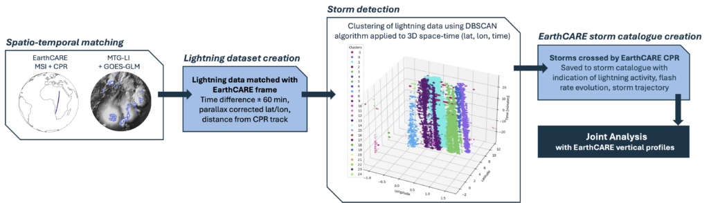
Method overview
A short animation illustrates how geostationary lightning detections evolve in the Gulf of Guinea while EarthCARE’s MSI captures the storms from above during the overpass.
A methodology flowchart outlines the main processing steps:
- Spatio-temporal matching of LI/GLM lightning to EarthCARE orbit
- Creation of EarthCARE-like frames with colocated lightning data
- DBSCAN clustering in 3D (latitude–longitude–time) to identify individual storm objects
- Extraction of storm descriptors: lightning activity and evolution, storm trajectory, CPR-track distance, etc.
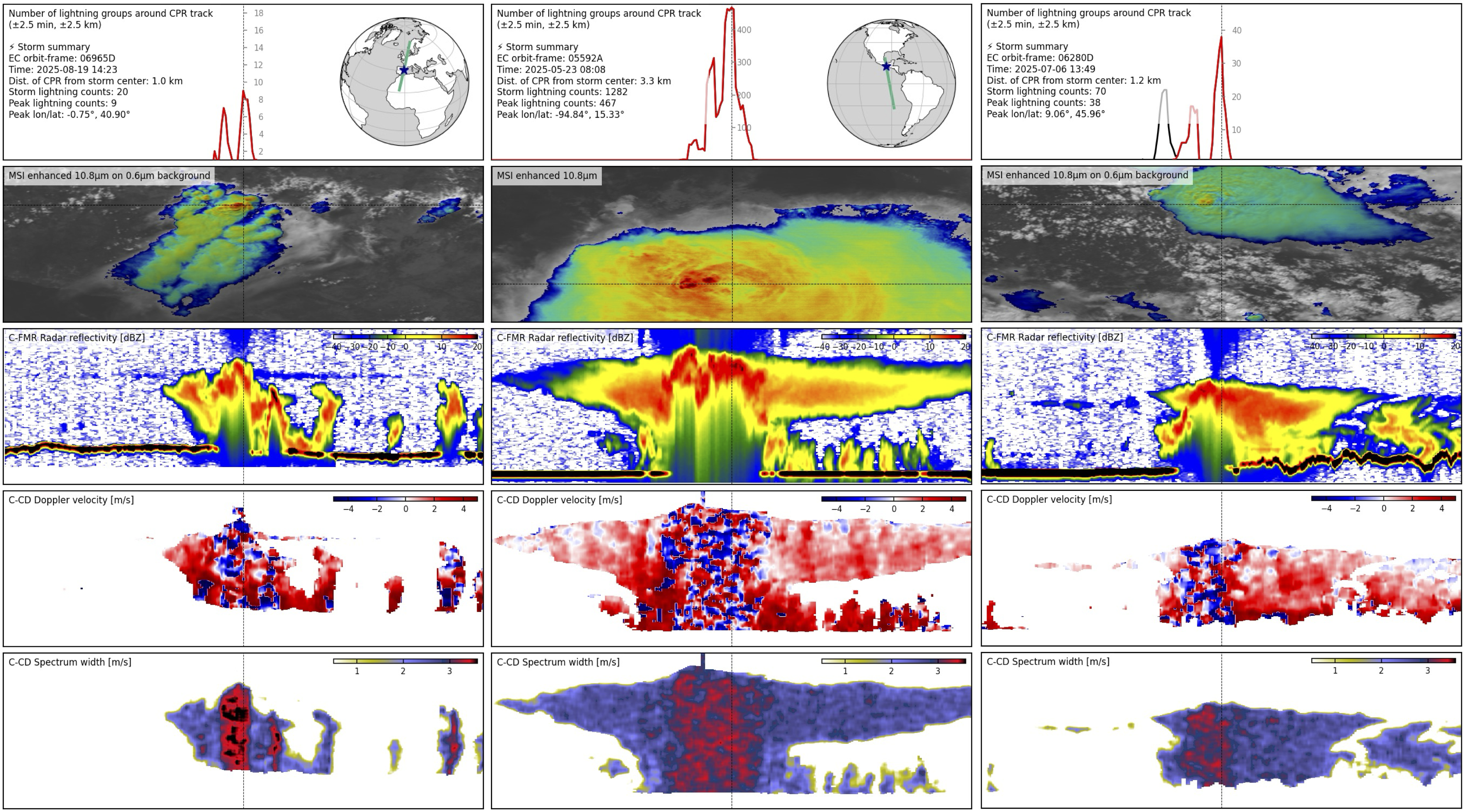
Early results and outlook
Initial examples from the storm catalogue show that lightning activity often aligns with EarthCARE’s radar-inferred dynamically active storm cores, even in the presence of attenuation and multiple scattering. CPR Doppler velocity variability and spectrum width highlight regions of strong vertical motion and turbulence, while MSI and ATLID provide valuable context on cloud-top structure and surrounding aerosol layers.
As EarthCARE data record grows, the catalogue will expand across regions and seasons, supporting research on storm evolution, land–ocean and tropical–midlatitude differences, and conditions leading to lightning production. The dataset will also form a foundation for model evaluation, convection–lightning coupling studies, and integration with additional space- and ground-based observations.
Connect:
LinkedIn: Blanka Piskala