
Developing a Machine Learning Framework for 1-km High-Resolution Satellite Precipitation Estimation
- Project by: Science Hub Team
- February 3, 2025
Satellite-based precipitation estimation offers a valuable alternative to ground-based measurements due to its high spatial and temporal resolution, near-real-time accessibility, and ability to provide continuous estimations. Two primary methodologies for satellite precipitation estimation are the top-down and bottom-up approaches. The top-down approach estimates precipitation based on atmospheric and cloud properties, as exemplified by globally available products like IMERG, PERSIANN, CMORPH, and CHIRPS. In contrast, the bottom-up approach estimates precipitation indirectly using soil moisture observations, with methods like SM2RAIN leveraging soil moisture variability to infer precipitation. The fundamental difference between these approaches lies in their measurement strategies. The top-down approach provides instantaneous precipitation estimates, which may result in underestimations. Meanwhile, the bottom-up approach yields accumulated rainfall estimates over the interval between consecutive soil moisture observations, reducing the likelihood of missing precipitation events, albeit through an indirect method.
Despite advancements in satellite-based precipitation estimation, challenges persist in achieving high-resolution precipitation data. Most global satellite precipitation products are limited to a spatial resolution of approximately 4 km, primarily due to the constraints of current LEO and GEO sensors. However, recent developments in satellite soil moisture products—such as Sentinel-1 (S1), which offers 1-km spatial resolution—open new avenues for bottom-up approaches in high-resolution precipitation estimation.
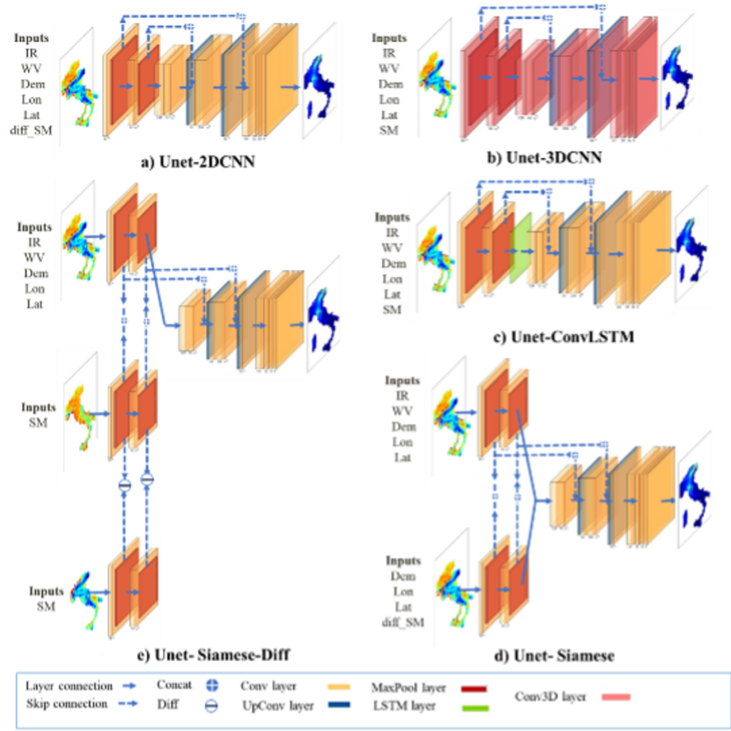
This study aims to integrate top-down and bottom-up approaches within a machine learning (ML) framework to produce high-resolution (1 km) daily precipitation estimates, leveraging the strengths of both methodologies. Our approach combines the direct relationship between cloud properties and precipitation derived from top-down methods with the high spatial resolution provided by bottom-up methods. Several deep learning architectures are employed in this study, including 2D CNN (Two-Dimensional Convolutional Neural Network), 3D CNN (Three-Dimensional CNN), ConvLSTM (Convolutional Long Short-Term Memory), Siamese networks, and Siamese-Diff (Figure 1). Various Earth observation (EO)-based datasets are utilized as features for training the model, including the IR channel (11 μm) and WV channel (6.7 μm) from GEO satellites, two satellite-based soil moisture (SM) products—namely, the Advanced Scatterometer (ASCAT) SM and Sentinel-1 Radiative Transfer Model (S1-RT1)—as well as elevation and geographical coordinates. Ground-based observational data are used as reference data to train the model and serve as a benchmark for evaluating its performance.
We conduct a comprehensive analysis of the output from our proposed model, comparing it with IMERG, a state-of-the-art global precipitation product. The results reveal that our machine learning (ML) model consistently outperforms IMERG across all evaluated metrics (Results are not shown here; see Reference 1 for details.).
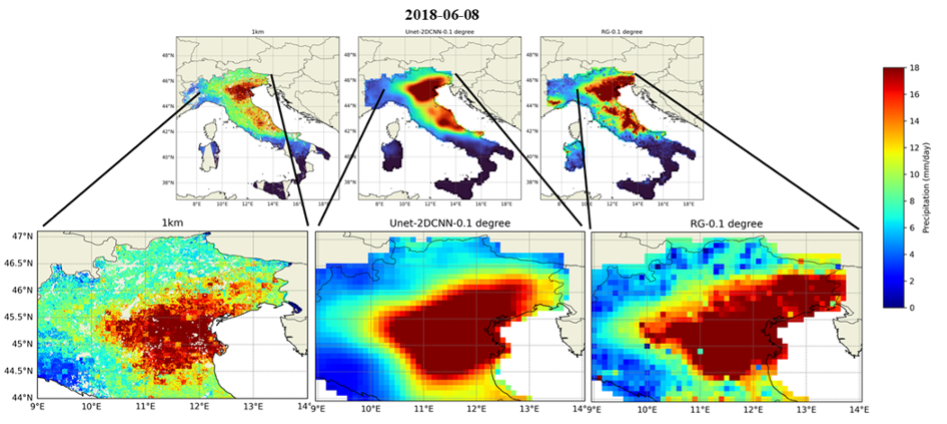
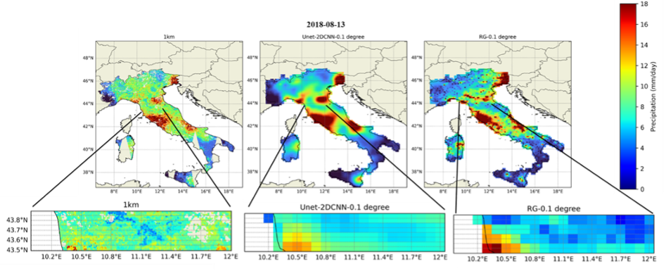
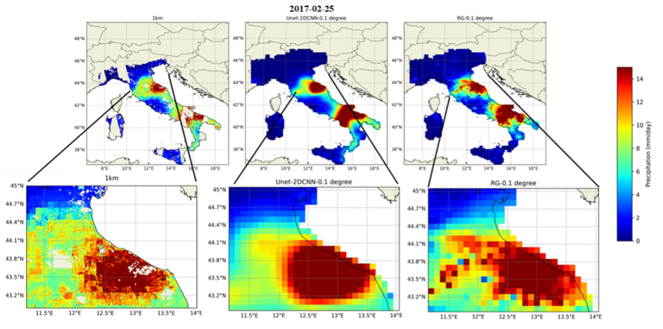
Figure 2 presents a spatial comparison of precipitation estimates from the ML model at 1-km and 0.1-degree (10 km) resolutions, as well as observed rain gauge (RG) data, for three selected events. This visual analysis underscores the distinct advantages of high-resolution (1-km) precipitation estimates. The 1-km outputs capture significantly finer spatial features, revealing localized variations in precipitation intensity that are often smoothed out or entirely absent in the coarser 0.1-degree product.
This approach effectively captures localized precipitation patterns across Italy and establishes a robust framework for the future development of global precipitation products at a 1-km high resolution.
You can find more details about this research in following publications:
- Mosaffa, H., Ciabatta, L., Filippucci, P., Sadeghi, M., & Brocca, L. Hr-Precipnet: A Machine Learning Framework for 1-Km High-Resolution Satellite Precipitation Estimation. Available at SSRN 4795786., https://dx.doi.org/10.2139/ssrn.4795786
- Mosaffa, H., Filippucci, P., Ciabatta, L., Massari, C., & Brocca, L. (2023). Application of deep convolutional neural networks for precipitation estimation through both top-down and bottom-up approaches (No. EGU23-15575). Copernicus Meetings.
This research is carried out by Hamidreza Mosaffa.